 National Maritime College
Your boating education and training partner
Your boating education and training partner
The IALA Buoyage System is a worldwide standard sea mark system used in navigation to mark the edge channels. These road signs on the water are made up of five buoy types- cardinal, lateral,isolated danger, special and safe water marks. These buoys and marks indicate where safe water lies and where you should navigate safely within a channel. Always refer to a local chart to identify where potential hazards may be.
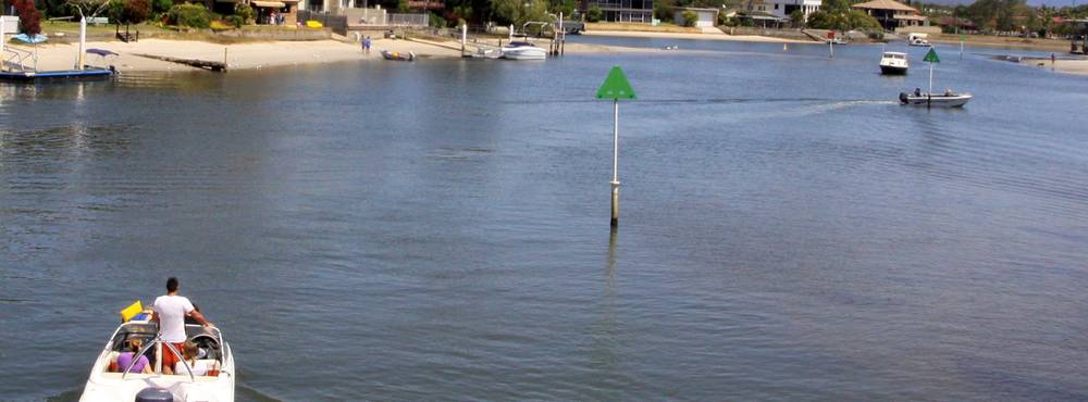
These show well-established channels and indicate port (left) and starboard (right) sides of the channels. Port marks are a red can shape. At night, a red flashing light may be shown. Starboard marks are a green conical shape. At night a green flashing light maybe shown.
Coloured yellow and black each indicates where there is deep water close to a danger and they show this relative to the compass. NORTH - white light continuous quick flashing light. Pass to North. SOUTH - white light 6 quick flashes + 1 long flash. Pass to South. EAST - white light 3 quick flashes. Pass to East. WEST - white light 9 quick flashes. Pass to West.
Indicates an isolated danger, such as a submerged rock. It tells you not to pass too close. Coloured black with one or more horizontal red bands. If lit at night it shows a group of two white flashes. The top mark has two round spheres.
Indicates a special area which should be kept clear of. Coloured yellow, if lit at night it shows a flashing yellow light. The top mark is a single yellow cross. Check your chart to find out what is special in the area you are boating in.
Safe water marks - are red and white striped beacon or buoy, often an isophase or occulting white light. It is used to signify that you [are in safe waters. This sea mark implies that open, deep and safe water lies ahead, though it is sometimes used to indicate the start and end of a buoyed section of a continuous narrow channel or a line of these marks can be used to mark a safe route through shallow areas. In Sydney Harbour it is used as a 'centre line of the channel' and vessels are required to leave it to port when navigating past Bradley's Head in either direction. Pass this mark to port when traveling up (coming in from sea) or, down stream (going out to sea)
New Danger Marks (also known as Emergency Wreck Marking Buoys) are used to identify newly discovered hazards such as a sandbar, rock, reef or wreck which has not already been marked on boating maps or nautical charts. The new danger mark displays blue and yellow vertical stripes in equal number dimensions around the mark.

When entering harbour (up stream) the red port mark should be kept on the vessel's port (left) side the green mark on the vessel's starboard (right) side.
When leaving harbour (down stream) the red port mark should be kept on the boat's starboard (right) side and the green mark on the vessel's port (left) side.

© 2020 National Maritime College. All Rights Reserved. ACN 110 084 145. RTO Number:90984
Subscribe to the Bowline Newsletter to get the latest information and training news from the College. It's filled with course information and boating advice. Get a taste for what is coming up, be the first to get information on events and enjoy special offers open to subscribers only.


